
I love making a trip to the Eastern Sierra during late September and early October. The leaves are changing, the air is crisp, and it’s my last hurrah for the warm hiking season.
I’d never hiked out of Independence before, so…why not? I looked at a map, saw a short-ish approach to alpine lakes, and I was sold. It would be an 11 mile hike. The first 4 miles scoots past 4-5 lakes and is a steady incline from 9000′ up to over 11,700′ at the pass. Then you lose about 800 ft on the 1.5 mile drop down to Kearsarge Lakes.
I headed out of Fresno dark and early on a Saturday after eating my usual weekend waffle. I love doing that. I get a great sleep in my own bed Friday night, and I get a head start before any Saturday traffic. That’s the one thing my early morning work shift is good for.
It’s just shy of 5 hours from Fresno to Onion Valley Campground, and I believe I arrived around 8 or 9 AM. I knew there would be a few showers and even some flurries, but I was ready for the weather. I had too many layers in my pack, and I was excited to see my first snowflakes of the season.

Sun rising over the Sierra
One of the COOLEST things about hiking out of Independence is that you’re only 20 miles east of the end of Highway 180, which ends at Kanawyers in Kings Canyon National Park. A 20 mile hike up and over the Sierra. That’s amazing to me. One day, I want to figure out transportation to get dropped off at either Onion Valley or Kanawyers and hike over the mountain range. Someone call me an Uber!
Anyway, the sun came up over the mountains and started to briefly illuminate the gold leaves. It was short-lived because clouds were already forming. It wasn’t long into the hike before I started to see graupel (looks and feels like Dippin’ Dots).

Few splashes of color in Onion Valley
There were many others on the trail, so I was glad I wasn’t the only one continuing to hike despite the not-so-perfect weather.

Sun, clouds, graupel, repeat.
I passed a small and what I assume is an unnamed lake, then found myself stopping to spend some time to enjoy Gilbert Lake.

Gilbert Lake

Love alpine lakes 🙂

Gilbert Lake
Right after was Flower Lake, Heart Lake, and Big Pothole Lake. Then I decided to just trudge up the rest of the way to the pass without stopping.

Kearsarge Lakes from Kearsarge Pass
There were a few groups hanging out at the top of the pass, and I soon found out why. Not only was the view incredible, but it was also the spot where continuing on any further meant being on the windward side and battling a mighty breeze.

Big Pothole Lake
I decided it was only a mile and a half down, so how bad could it be? I added the rest of my layers and started down the hill. About 5 minutes in my hands started going numb in my gloves. I realized the one article of clothing I’d forgotten was my extra mittens. I knew my hands wouldn’t ever warm up in my thin gloves, so I decided to turn back. Bummer.
I hung out at the top of the pass again, which is also the eastern border of Kings Canyon & Sequoia National Parks. I spent a little time chatting with a few people up there. I love doing that. You never know who you’ll meet in a random wilderness location! My hands eventually warmed up, and I decided to head back to the car. 8 miles was still a really good hike, and I felt like making the drive to the East Side for that was worth it.

11,700 ft
I drove back south on Highway 395 to my usual BLM spot to spend the night. I ended up going back to Mobius Arch for some Milky Way photos, then found a place to sleep for the night.

Milky Way, Mobius Arch, stranger.

Milky Way, Shark Fin
It was prime climbing season for Alabama Hills, and I actually had to blindly drive around the area for a while before finding a spot out of the way of everyone else. Once again, my awesome air mattress/window screen setup worked like a charm, and I got a great night of sleep.
I was greeted by a beautiful scene the next morning, played with the idea of doing one more hike while I was over there, but ultimately decided to head back to CL. It was a quick weekend, but full of action, weather, and nature. Just how I like it.

Eastern Sierra

Morning view from Alabama Hills

Morning weather!

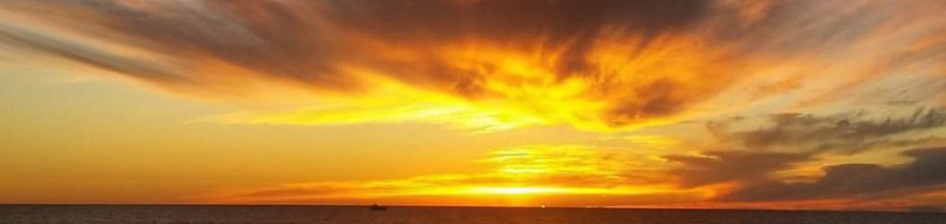
Cotton candy sky


Don’t worry, it was deserted.
As long as I have been alive, which is over 50 years the word has been pronounced- Ker saj. Kinda like the word massage as in to get sore muscles rubbed out.
Totally awesome photography on your part!
Totally awesome photography on your part!
Thank you for allowing me to be a part of your adventures. I love the photography, as it is always stunning. Your description of the hike help me to be able to go with you every step of the way.
I share your excitement about that first snow of the winter. I still feel that way with every first snow here.
Once again. Thank you for a great job.
Heyyyyyyyyyyyyyyyyyyyyy🤗🤗Lauren 🤗🤗great hear from be awhile love see beautiful pictures too I one biggest fan 🤗🤗Alex too she great 🤗🤗love you hiking segment too